RadarOmega — Weather Radar App & Weather Station App
RadarOmega is a consumer weather app built by the team behind cyclonePort — combining high-resolution NEXRAD Doppler radar, real-time NWS alerts, lightning detection, satellite imagery, numerical weather models, and live cyclonePort station sensor data and camera feeds in a single cross-platform app used by 261,000+ subscribers across the United States, Canada, Germany, Australia, and South Korea. It wraps the same professional-grade weather data tools that broadcast meteorologists and emergency managers rely on into an interface designed for everyday users.
Contents
01 What Is RadarOmega — and Why Is It Different?
02 The cyclonePort + RadarOmega Integration — Why It Matters
03 RadarOmega Radar Features — What the App Provides
04 Subscription Tiers — Base, Gamma, Beta, Alpha
05 RadarOmega as a Weather Station App — Accessing cyclonePort Data
06 Cross-Platform Access — Phone, Tablet, and Desktop
07 Alert System — Push Notifications and Safety Protocols
08 RadarOmega vs. Other Consumer Weather Apps
09 Operational Use Cases — Who Uses RadarOmega
10 Getting Started with RadarOmega and cyclonePort
11 Platform Specifications
12 Frequently Asked Questions
- 261,000+
Subscribers
- iOS · Android · Desktop
- Native cyclonePort
Station Data
- US · CA · DE · AU · KR
01 What Is RadarOmega — and Why Is It Different?
RadarOmega is a consumer weather application developed by SDS Weather (Storm Damage Services, Inc.) — the same team that created cyclonePort. Available on iOS, Android, Windows, Mac, and Linux, RadarOmega wraps professional-grade weather data into a user-friendly interface that everyday users can understand: high-resolution NEXRAD Doppler radar with dual-polarization products, numerical model data (HRRR, NAM, GFS, ECMWF) for advanced subscribers, satellite imagery, SPC convective outlooks, NHC tropical products, MRMS precipitation analysis, and — uniquely — live sensor data and camera feeds from the cyclonePort ground-truth station network.
RadarOmega is built around storm tracking, severe weather monitoring, and situational awareness — the kind of tool that lets you see what’s actually happening when weather threatens your area, not just what a generalized forecast says. With 261,000+ subscribers across five countries, it has the depth of data that broadcast meteorologists put on air and the accessibility that any household can use to make informed decisions about their safety.
The crucial distinction from every other weather station app Every weather station manufacturer — perryweather.com, baronweather.com, company.weatherstem.com, vaisala.com — provides a companion app that shows you your station data. cyclonePort provides that too. But only cyclonePort’s station data lives natively inside RadarOmega — a weather app that 261,000+ users already trust. You do not switch between a weather station app and a radar app. You see both simultaneously, on the same map, in a single interface. |
02 The cyclonePort + RadarOmega Integration — Why It Matters
The relationship between cyclonePort and RadarOmega is not an integration between two separate products — it is a native connection between the hardware and software built by the same team, for the same purpose. Every cyclonePort station appears on the RadarOmega map by default; hardware owners have the option to set their station’s visibility to private at their discretion. There is no separate dashboard login, no API key configuration, no data connector to maintain. The station is simply there, in the app, the moment it comes online.
Note: cyclonePort hardware owners actually operate their stations through cyclonePORT Enterprise — a separate enterprise application that is powered by the same RadarOmega data. Consumer-level RadarOmega users can view public cyclonePort camera and data feeds. Camera control and station management are reserved for authorized enterprise users in cyclonePORT Enterprise.
What You See When You Tap a cyclonePort Station Marker
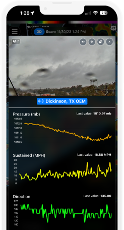
Tapping any public cyclonePort station marker on the RadarOmega map opens a live panel displaying:
- All current sensor readings: temperature, humidity, heat index, dew point, wind speed (sustained and gust), wind direction, barometric pressure and trend, rainfall rate and accumulation, lightning strike detection, WBGT (where installed)
- Trend sparklines: intuitive display of how each parameter has changed over the past 20 minutes — not just the current value but whether it is rising or falling and how fast
- Current WBGT threat level: displayed on the station readout where WBGT is installed
- Live PTZ camera feed: the live HD camera stream from the station, viewable by all RadarOmega users on public stations. Camera control (pan/tilt/zoom) is not available through RadarOmega at any subscription tier — that capability is reserved for authorized users in cyclonePORT Enterprise.
- Historical sensor chart access: the data archive for a unit is available to authorized members of the organization that owns the unit. The amount of data archived depends on the data storage package the hardware owner has chosen.
All of this appears alongside the NEXRAD radar loop, NWS warning overlays, and lightning detection that RadarOmega provides — giving the operator the regional storm picture (radar) and the ground-truth local reality (station sensors and camera) on the same screen.
The Ground-Truth Value of Combined Views
The operational value of this combination is clearest in the moments that matter most. A severe thunderstorm warning is displayed on the RadarOmega map. The radar shows the storm cell approaching. The user taps a nearby public cyclonePort station — and sees how conditions are changing in real time as the storm approaches, along with a live camera feed showing what’s actually happening on the ground. The NWS warning gives you the authoritative regional threat; the station gives you the local confirmation. The NWS warning always takes top priority — RadarOmega’s hyper-local tools help you better understand the immediate threats around you, not discount NWS warnings in any way.
A real user describing the cyclonePort + RadarOmega combination: “The inclusion of private gap filler radars and micro weather data from cyclonePort stations is a game changer. Being able to physically see the storm coming through the extensive camera and sensor network gives you eyes on the ground. No need to use any other radar, or monitoring software.” |
03 RadarOmega Radar Features — What the App Provides
RadarOmega’s radar capabilities are the foundation of the platform — the reason it has 261,000+ subscribers independent of its cyclonePort integration. For cyclonePort customers, these capabilities give the station data its context: what is approaching, how intense it is, how fast it is moving, and how it compares to what the on-site sensors are already showing.
Single-Site NEXRAD Doppler Radar Products
- High-resolution single-site radar: Level 2 and Level 3 products at the highest available resolution — hi-res reflectivity, hi-res velocity, storm relative velocity, correlation coefficient, differential reflectivity, and dual-polarization products for hail and precipitation type discrimination.
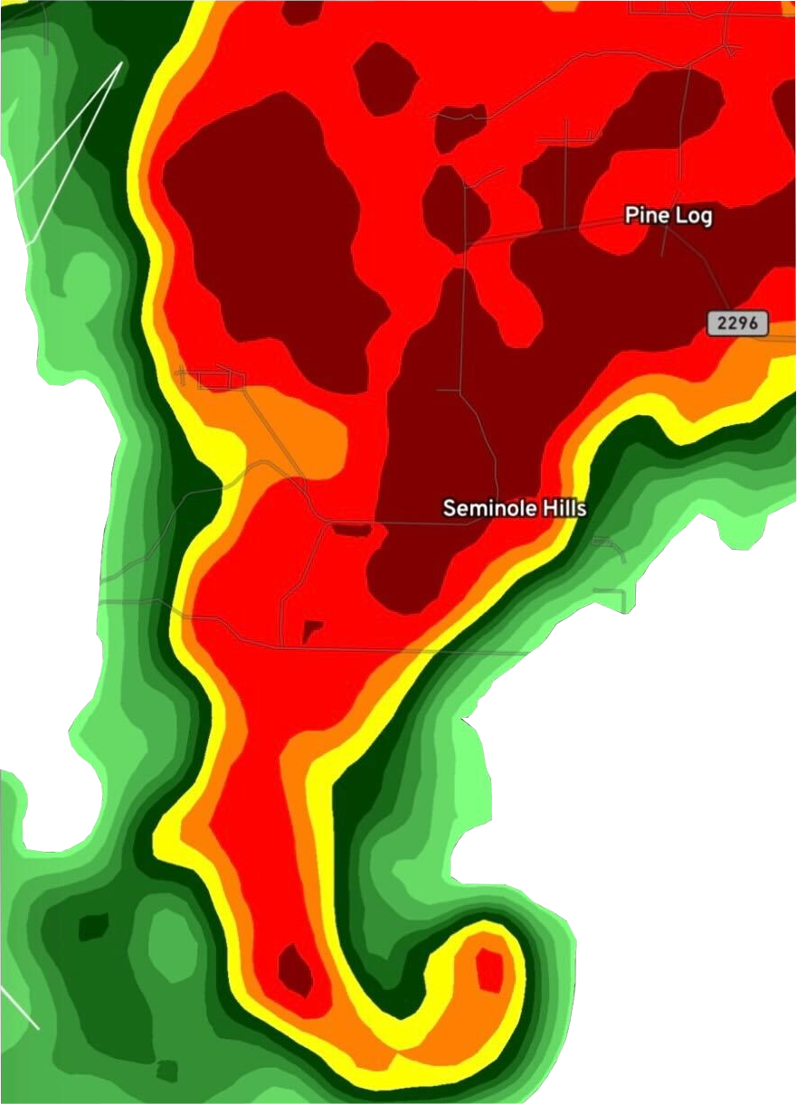
- NEXRAD attributes — automatic tornado vortex signature (TVS) detection: RadarOmega surfaces NEXRAD-derived attributes that automatically detect and indicate tornado vortex signatures (TVSs) and other automated radar-derived features within the data stream. Users can see flagged TVS locations directly on the radar map.
- Velocity and shear products: Velocity products can be used to identify rotation signatures within storms — mesocyclone signatures that can indicate tornado formation.
- Hail core identification via dual-polarization: Dual-pol radar products (correlation coefficient, differential reflectivity, specific differential phase) allow users to identify hail cores within storm cells.
- Custom storm track tool: Users can draw projected storm paths and receive estimated arrival times at saved locations. (Note: the Impact Times list generated by the custom storm track tool surfaces ETAs for built-in points along the track; custom locations can be inferred from the track but ETAs for custom locations are not explicitly displayed in the Impact Times list.) (#3)
- 3D volumetric radar: Available to Alpha subscribers — view the full vertical structure of a storm cell, revealing a supercell’s hook echo at multiple altitude slices simultaneously.
- Historical radar archive: 7 days for base users; 30 days for Gamma; 90 days for Beta and Alpha.
- Animated frames: 30 frames for base users, up to 250 frames for Alpha subscribers.
MRMS Products (Multi-Radar Multi-Sensor)
Satellite Imagery
Visible, infrared, and water vapor satellite imagery (Gamma and above) at high resolution, with animation capability. Visible satellite products show cloud cover and structure; infrared shows cloud top temperatures and convective activity; water vapor shows atmospheric moisture transport.
- Geostationary Lightning Mapper (GLM): Real-time total lightning (in-cloud and cloud-to-ground) from GOES satellites, overlaid on radar and satellite.
- Mesoscale satellite sectors: Ultra-high spatial and temporal resolution satellite sectors for active severe weather areas, updated every 30–60 seconds during severe weather events.
Numerical Weather Models (Alpha subscribers)
Alpha subscribers access full numerical weather model output directly in RadarOmega — the same model data that professional meteorologists use for forecasting, overlaid on the same map as radar and station data:
- Short-range regional models: HRRR (High Resolution Rapid Refresh, 3-km resolution, hourly updates), NAM (North American Mesoscale, 3-km and 12-km), RAP (Rapid Refresh)
- Global models: GFS (Global Forecast System, 12-km), ECMWF (European Centre for Medium-Range Weather Forecasts)
- Hurricane models: HWRF and HMON
- Parameters: Reflectivity, wind speed, precipitation accumulation, temperature, dew point, and more — with contour overlay and customization
Weather Products and Outlooks
- 60+ NWS weather alert types: RadarOmega delivers tornado warnings, severe thunderstorm warnings, flash flood warnings, plus the full range of NWS storm-based and non-precipitation warnings/watches/advisories — 60+ alert types covered in total.
- SPC (Storm Prediction Center): Convective outlooks (Day 1 through Day 8) with significant severe hatching, mesoscale discussions, tornado and severe thunderstorm watches
- NHC (National Hurricane Center): Tropical weather outlooks, active tropical cyclone tracks, storm surge watches/warnings, Hurricane Hunter aircraft track data
- WPC (Weather Prediction Center): Excessive rainfall outlooks, winter weather forecasts and Winter Storm Severity Index, WPC surface analysis
- Fire Weather: Fire weather outlooks and weekly drought monitor
04 Subscription Tiers — Base, Gamma, Beta, Alpha
RadarOmega uses a tiered subscription model that provides progressively more powerful data tools. The base application is available at a one-time purchase price and includes full cyclonePort network access — public station sensor data and live camera feeds — alongside core radar functionality. Subscriptions unlock additional data layers and archive depth.
| Tier | Features |
|---|---|
| Base (one-time purchase) | HIGH-RESOLUTION SINGLE-SITE RADAR: 30 frame animations, 7-day radar history. MRMS reflectivity only. ALERTS: Real-time NWS storm-based warnings with flash animation and in-app sound. OUTLOOKS: SPC convective, NHC tropical, WPC excessive rainfall, fire weather, drought. METARs: Aviation weather observation data layer. NEXRAD hail history, spotter network locations, power outage layer. MAP: 10 map type presets; zoom to building level. LOCATIONS: 15 custom saved locations. TOOLS: Drawing, data viewer, and distance measurement tools. CYCLONEPORT: Full view-only access to public cyclonePort station network — live sensor data and camera feeds. PUSH NOTIFICATIONS: GPS location alerts for storm-based warnings. |
| Gamma | EVERYTHING IN BASE PLUS: Hi-resolution satellite data (visible, infrared, water vapor). MRMS data — full access. GLM lightning for mesoscale and storm satellite sectors. National Digital Forecast Database (NDFD). 75 frame animations. Dual-view radar with 30 frames. 30-day radar history. Radar smoothing. Extruded 3D radar and satellite. 6-month storm report archive. Upload 3 custom color tables. 30 custom locations. Desktop access (Windows, Mac, Linux). |
| Beta | EVERYTHING IN GAMMA PLUS: 150 frame animations. Dual-view for radar and satellite. 90-day radar history. 5-year storm report archive. Upload 8 custom color tables. 75 custom locations. Desktop access included. |
| Alpha | EVERYTHING IN BETA PLUS: VOLUMETRIC RADAR: Full 3D storm structure visualization. MODELS: Full numerical weather model suite — HRRR, NAM3KM, NAM12KM, RAP, GFS, ECMWF, HWRF, HMON — with contour overlay and customization (2 data sets simultaneously). 250 frame animations. 10-year storm report archive. Upload custom color tables (advanced). 150 custom locations. Site location monitoring (live monitor). Desktop access included. |
Subscriptions are available as monthly or annual plans starting at $4.99/month. All paid subscriptions include desktop access (Windows, Mac, Linux). cyclonePort station data and camera feeds on public stations are included in the base application — no subscription required to view your local cyclonePort network in RadarOmega.
05 RadarOmega as a Weather Station App — Accessing cyclonePort Data
For people exploring nearby cyclonePort station feeds, RadarOmega is the consumer weather app where public cyclonePort data appears natively on the same map as radar. For cyclonePort hardware owners, the actual operational interface is cyclonePORT Enterprise — a separate enterprise application that has all the same features as RadarOmega plus enterprise-specific tools. cyclonePORT Enterprise is powered by RadarOmega data. Hardware owners do not operate their stations through RadarOmega.
Station Dashboard Features (RadarOmega view)
- Live sensor display: All current readings — temperature, humidity, heat index, wind speed and gusts, wind direction, pressure and trend, rainfall, lightning proximity, WBGT — updated every second
- Trend sparklines: Each parameter shows direction and rate of change over the past 20 minutes
- Heat index and WBGT category display: NWS heat danger level and GHSA/NFHS/NCAA WBGT category displayed alongside the reading
- Live PTZ camera (view only): HD camera stream available within the station panel. Camera control is not available to RadarOmega users at any tier — that capability is reserved for authorized users in cyclonePORT Enterprise.
Customizable cyclonePort Dashboard (multi-camera view)
For organizations with multiple cyclonePort units, the cyclonePORT dashboard is a separate tool in the side menu (not on the map) that displays multiple camera views simultaneously in one place. Each camera tile can be selected to view individually and see that unit’s sensor readouts. This is useful for organizations that need to keep eyes on several locations at once. Note: this dashboard shows multiple camera views simultaneously, but sensor data is shown when an individual unit is opened — there is no view that displays sensor readings from multiple units at the same time.
You can also have multiple cyclonePort unit displays open within the desktop version simultaneously if you want to monitor parallel readings — but that is not a dedicated “multi-station view” feature.
Customizable cyclonePort Dashboard (multi-camera view)
06 Cross-Platform Access — Phone, Tablet, and Desktop
RadarOmega is available across all major platforms — but the cross-platform mechanics deserve a clear explanation because they differ between the base application purchase, the subscription, and the desktop application:
- Base application: Available on both iOS and Android, purchased separately on each platform. Purchasing the base app on iOS does not automatically purchase it on Android, and vice versa. If you want the mobile app on both an iPhone and an Android tablet, you’ll buy the base app twice — once per platform.
- Subscription (Gamma / Beta / Alpha): Cross-platform. Once you own the base app on a platform, your subscription works on that platform. The subscription itself can be used across iOS, Android, and desktop simultaneously. However, changes to the subscription (upgrading tiers, billing changes, cancellation) must be made through the platform on which the subscription was originally purchased.
- Desktop application (Windows, Mac, Linux): Free download from radaromega.com — no separate purchase. Desktop access is included with any paid subscription. This is true cross-platform: you do not need to “buy” desktop the way you buy iOS or Android.
| Platform | Details |
|---|---|
| iOS (iPhone and iPad) | Native app from the Apple App Store. Full feature set on iPhone; quad-panel radar layout available on iPad for Alpha subscribers. |
| Android (Phone and Tablet) | Native app from Google Play Store. Full feature set on Android phones and tablets. Adaptive layout scales to device screen size. |
| Windows desktop | Downloadable application from radaromega.com. Free; subscription required for advanced features. Multi-monitor support. |
| Mac desktop | Downloadable application from radaromega.com. Native macOS application. |
| Linux desktop | Downloadable application from radaromega.com. Unusual in the weather app market — supports Linux-based environments. |
| Account sync | A few settings sync across devices via your RadarOmega account — custom saved locations, alert configurations, and account-level preferences. Most settings do not sync — visual display preferences (color tables, map style, layer choices, animation speed) are device-specific. This is intentional: people configure visual display differently on phone vs. desktop. |
07 Alert System — Push Notifications and Safety Protocols
RadarOmega’s alert system is built around one absolute principle: NWS warnings always take top priority. RadarOmega delivers NWS storm-based warnings to all users via push notification — these are the authoritative regional threat warnings, and our hyper-local tools (radar, station data, camera feeds) help you better understand and respond to those NWS warnings, never to discount or override them.
NWS Storm-Based Warnings — Regional Situational Awareness
RadarOmega delivers real-time NWS storm-based warnings to all users via push notification — tornado warnings, severe thunderstorm warnings, flash flood warnings, plus the full range of 60+ NWS alert types — with GPS-based delivery (alert fires when a warning polygon intersects your location) or custom location-based delivery (alert fires for any of your saved locations).
- Flash animation: When a warning is active, the warning polygon flashes on the radar map with a bright color.
- In-app sound alert: A distinctive audio alert fires when a new warning is issued.
- Non-precipitation watches and warnings: Extreme cold warnings, excessive heat warnings, wind advisories, dense fog advisories — all included alongside storm-based products.
cyclonePort Network Notifications — What’s Actually Sent
The push notification model for cyclonePort sensor data is narrower than the original draft of this page suggested. To be accurate:
- Lightning push notifications: Available only to cyclonePORT Enterprise users, not to consumer-level RadarOmega subscribers. Configured through cyclonePORT Nexus. Incorporates lightning detected by the cyclonePORT network in addition to standard lightning detection sources.
- WBGT threat level: Displayed as a visual indicator on the cyclonePORT unit’s display when WBGT thresholds are crossed. This is not a push notification — it’s a visual cue on the readout itself.
- Other sensor thresholds (heat index, wind speed, pressure trend, wind chill): RadarOmega does not currently send push notifications when these thresholds are crossed. There is no general sensor-threshold notification capability in RadarOmega at any subscription tier.
The relationship between NWS warnings and on-site observations. An NWS severe thunderstorm warning is the authoritative regional warning — it should always be taken seriously, even when the storm core is tracking some distance from your specific location. RadarOmega’s hyper-local tools (radar zoom, station sensor data, live camera) help you understand what the warning means at your specific spot: how close the storm is, whether it has already arrived, what intensity is hitting you right now. They are tools for responding to NWS warnings with better information — not for second-guessing them. |
08 RadarOmega vs. Consumer Weather Apps
The weather app landscape spans from general-purpose consumer apps (The Weather Channel, AccuWeather, Weather Underground) to more specialized weather apps. RadarOmega sits in the consumer market the same way those other apps do — targeted at the general public — but provides significantly more data and higher data quality. For people who want to make more informed decisions about weather affecting their household, work, or activities, RadarOmega gives access to the underlying data that other consumer apps simplify or hide.
| Capability | Consumer Weather Apps | RadarOmega |
|---|---|---|
| Radar resolution | Smoothed, reduced resolution for visual appeal | Full NEXRAD resolution — Level 2 and Level 3, dual-polarization |
| Radar data source | Mosaic composites, often delayed or smoothed | Single-site high-resolution NEXRAD; MRMS mosaic available for subscribers |
| Model data | None or simplified forecasts | Full suite (Alpha): HRRR, NAM, GFS, ECMWF, RAP, HWRF — with contour overlays |
| Satellite imagery | Basic cloud cover | Full GOES visible, infrared, water vapor; GLM lightning; rapid-scan mesoscale sectors |
| SPC / NHC products | Summary only | Full SPC outlooks, mesoscale discussions, NHC tropical products, Hurricane Hunter tracks |
| Ads | Heavy ad load on free tiers | No ads on any tier |
| On-site weather station data | None | Native cyclonePort sensor data on public stations — temperature, heat index, WBGT, wind, lightning, pressure, camera |
| Live camera access | None | HD PTZ live stream from public cyclonePort stations (view-only for RadarOmega users) |
| Desktop version | No | Yes — Windows, Mac, Linux included with paid subscription |
| Professional community | General public | 261,000+ subscribers across five countries — same general public audience these other apps target |
09 Operational Use Cases — Who Uses RadarOmega
Broadcast Meteorology and Television Weather
RadarOmega is used by broadcast meteorologists for on-air weather coverage — its full-resolution radar products, SPC and NHC integration, and customizable display options provide the data quality that television weather demands. For broadcast stations with cyclonePort cameras deployed across their viewing area, RadarOmega provides both the radar context and the live visual ground-truth from those cameras — all in the same platform used for on-air visualization. HD camera feeds from public cyclonePort stations can be embedded directly into broadcast coverage.
Storm Chasers
RadarOmega’s professional-grade radar products — Level 2 data, dual-polarization products, storm relative velocity, MRMS rotation tracks, volumetric radar, and NEXRAD attributes (with automatic TVS detection) — make it a primary tool for storm chasers. A typical use: a chaser monitoring storm-relative velocity products spots radar-estimated TVS attributes overlaid on a storm cell in real time and adjusts position accordingly. The cyclonePort network provides surface observations from public stations along chase routes, supplementing the radar picture. The large and active storm chasing community within the RadarOmega user base creates a network effect: when severe weather events occur, extensive community engagement improves awareness of conditions across the affected area.
Severe Weather Research
University programs and severe weather researchers use RadarOmega’s full radar and model data suite — particularly the Level 2 NEXRAD data, MRMS products, dual-polarization fields, and numerical model output — for case studies, mesoscale event reconstruction, and microclimate analysis. RadarOmega’s historical radar archives (up to 90 days for Beta/Alpha subscribers) support post-event analysis.
Households, Outdoor Enthusiasts, and Everyday Users
The largest single user group is the general public — people who want a clearer picture of weather affecting their home, commute, or weekend plans than a generalized forecast app provides. A parent checks the radar before sending kids to school in a developing storm. An outdoor enthusiast monitors lightning proximity before heading out for a hike. A homeowner tracks an approaching squall line from the couch to know when to bring patio furniture in. RadarOmega’s interface is designed so these everyday decisions don’t require professional meteorology knowledge — the app surfaces the data clearly and lets users interpret it at whatever depth they want.
Schools, Emergency Management, Construction — via cyclonePORT Enterprise
For organizations using cyclonePort hardware to drive safety operations — school athletics, municipal emergency management, construction sites, utility operations — the day-to-day operational interface is cyclonePORT Enterprise, not RadarOmega. cyclonePORT Enterprise includes all RadarOmega capabilities plus enterprise-specific tools (cyclonePORT Nexus for org-level policy, multi-camera dashboard, lightning monitoring notifications, role-based access). RadarOmega is what the broader community around those organizations uses — parents checking conditions at the practice field, community members watching weather around a municipal location, contractors and subcontractors confirming on-site conditions from their phones.
10 Getting Started with RadarOmega and cyclonePort
For Consumer Users (most people)
- Download RadarOmega. Available free as a base application from the Apple App Store and Google Play Store. (Note: the base app is purchased separately on iOS vs. Android — owning it on one platform does not automatically grant it on the other.) Desktop version available free from radaromega.com.
- An account is not required to use the base application. Most core functionality works without signing in. An account is required if you want to: create custom saved locations, upload custom color tables, configure basic weather alert notifications, or purchase a subscription.
- View public cyclonePort station data. Public cyclonePort station markers appear on the RadarOmega map by default once you have the app installed. Tap any marker to see live sensor data, trend sparklines, and the live camera feed.
- Subscribe for additional data. The base application includes view-only access to public cyclonePort stations. Gamma, Beta, and Alpha subscriptions unlock additional radar history, satellite, model data, and platform features. Starting at $4.99/month.
For Enterprise / cyclonePort Hardware Customers
cyclonePort hardware is offered to enterprise clients at this time and does not use the RadarOmega consumer flow. Enterprise customers:
- Contact SDS Weather (via cyclonePort) to discuss requirements and qualify for cyclonePort hardware purchase.
- License activation is handled by an SDS Weather admin. Enterprise accounts do not use the consumer subscription model — your account is created and licensed for you.
- Use cyclonePORT Enterprise — the enterprise application that hardware customers operate their stations through. cyclonePORT Enterprise has all RadarOmega’s capabilities plus enterprise-specific tools.
- Configure organization policy in cyclonePORT Nexus — locations, lightning monitoring notifications, camera operator designations are all set at the org level through Nexus. (Per-unit alert rules are not configured through Nexus; lightning monitoring notifications and camera operator designations are.)
Most deployments go from contract to live data in approximately 2–4 weeks.
11 Platform Specifications
| Parameter | Specification |
|---|---|
| App Name | RadarOmega (also marketed as “RadarOmega: Doppler Radar App”) |
| Developer | SDS Weather Inc. (Storm Damage Services, Inc.) — same team as cyclonePort |
| Platforms | iOS (iPhone, iPad), Android (phone, tablet), Windows, Mac, Linux |
| Subscriber Count | 261,000+ active subscribers |
| Geographic Coverage | United States — full product suite (NEXRAD radar, NWS storm-based warnings, satellite, global models, SPC/NHC products). Canada — Environment Canada radar, NWS-equivalent weather alerts, global models. Germany, Australia, South Korea — radar and global models only (no NWS-equivalent local alert system). |
| Radar Data Sources | NEXRAD (US), Environment Canada, DWD (Germany), Bureau of Meteorology (Australia), KMA (South Korea) |
| Radar Products (single-site) | Reflectivity (base and composite), Base velocity, Storm relative velocity, Dual-polarization (ZDR, CC, KDP), NEXRAD attributes (automatic TVS detection) |
| Radar Products (MRMS) | MRMS composite reflectivity, MRMS hail, MRMS rotation tracks — Gamma+ subscribers (MRMS reflectivity only on base) |
| Satellite Products | GOES-East/West visible, infrared, water vapor (Gamma+); GLM total lightning; Mesoscale high-resolution sectors |
| Model Data (Alpha) | HRRR, NAM3KM, NAM12KM, RAP, GFS, ECMWF, HWRF, HMON — with contour overlays and customization |
| Weather Products | SPC (convective outlooks Day 1–8, mesoscale discussions, watches), NHC tropical suite, WPC (excessive rainfall, winter, surface analysis), Fire weather outlook, Drought monitor |
| NWS Alert Coverage | 60+ NWS alert types — storm-based warnings (tornado, severe thunderstorm, flash flood, etc.) plus non-precipitation watches/warnings/advisories. GPS-based and saved-location push notifications. Notification scope expands by subscription tier (FLAG #36 — cyops to confirm exact breakdown). |
| Radar Animation | Base: 30 frames / Gamma: 75 frames / Beta: 150 frames / Alpha: 250 frames |
| Radar History | Base: 7 days / Gamma: 30 days / Beta, Alpha: 90 days |
| cyclonePort Integration | Native — public station sensor data, derived metrics, live PTZ camera feed (view only), historical chart access for authorized organization members |
| Camera Access | Live PTZ stream viewable on public stations by all RadarOmega users. PTZ control is not available to RadarOmega users at any subscription tier — camera control is reserved for authorized users in cyclonePORT Enterprise. |
| Map Options | 10+ preset map types (Mapbox-derived); zoom to building level; dark, light, and satellite presentations; day/night layer. Custom Mapbox integrations are not supported. |
| Customization | Custom location lists (15 base / 30 Gamma / 75 Beta / 150 Alpha); custom color tables; custom storm track drawing and styling |
| Desktop Subscription | Desktop application download is free; included with any paid subscription |
| Subscription Starting Price | From $4.99/month for Gamma; account required (free) for paid features; subscription is cross-platform once base app is owned on each mobile platform separately |
| Account Requirements | Not required for base application use. Required for: custom saved locations, custom color tables, weather alert notification configuration, subscription purchase. |
| Settings Sync | Custom saved locations, alert configurations, and account-level preferences sync across devices. Visual display preferences (color tables, map style, layer choices) are device-specific and do not sync. |
| cyclonePort Enterprise | Separate enterprise application for cyclonePort hardware owners. Powered by RadarOmega data. Includes access to cyclonePORT Nexus for org-level policy management. cyclonePort hardware purchase is offered to enterprise clients only at this time. |
Feature availability and pricing may change. Visit radaromega.com for current subscription options.
Deploy cyclonePort and Get Your Station in RadarOmega Every cyclonePort station connects natively to RadarOmega — public station data, public camera feeds, no third-party integration. cyclonePort hardware is offered to enterprise clients; deployment in 2–4 weeks. RadarOmega itself is free to download for everyday users and is available to anyone on iOS, Android, Windows, Mac, or Linux. info@cycloneport.com · 844-737-9328 · cycloneport.com/contact |
12 Frequently Asked Questions
What is RadarOmega?
RadarOmega is a consumer weather application developed by SDS Weather Inc. — the same team behind cyclonePort. Available on iOS, Android, Windows, Mac, and Linux, it provides high-resolution NEXRAD Doppler radar, satellite imagery, numerical weather model data (HRRR, NAM, GFS, ECMWF for Alpha subscribers), SPC and NHC weather products, 60+ NWS alert types, and — uniquely — live sensor data and HD PTZ camera feeds from public cyclonePort weather stations. With 261,000+ subscribers across the US, Canada, Germany, Australia, and South Korea, it wraps professional-grade weather data into an interface designed for everyday users.
Is RadarOmega the app that comes with a cyclonePort weather station?
For people who want to view nearby cyclonePort station data, yes — RadarOmega is the consumer app where public cyclonePort station data appears natively on the map. For cyclonePort hardware owners, however, the operational interface is cyclonePORT Enterprise, not RadarOmega. cyclonePORT Enterprise is a separate enterprise application (powered by the same RadarOmega data) that hardware customers use to manage their stations, camera operator designations, and lightning monitoring notifications. All RadarOmega users can view live camera and data feeds from public cyclonePort stations in the network with no subscription necessary, just the base application.
What is the difference between RadarOmega and a regular consumer weather app?
Other consumer weather apps (The Weather Channel, AccuWeather, Weather Underground) show generalized forecasts and smoothed radar for a broad location. RadarOmega is built for the same general-public audience but provides significantly more data and higher data quality: full-resolution NEXRAD Doppler radar with dual-polarization products, MRMS national mosaic, satellite imagery, SPC outlooks, NHC tropical data, numerical weather models, and 60+ NWS alert types. Additionally, RadarOmega is the only consumer weather app where public cyclonePort weather station sensor data and live camera feeds appear natively.
What are the RadarOmega subscription tiers?
RadarOmega has a base application (one-time purchase) and three subscription tiers. Base includes high-resolution single-site radar, NWS storm-based warnings, SPC and NHC products, METAR data, view-only access to public cyclonePort stations, and 7-day radar history. Gamma adds hi-resolution satellite, full MRMS, NDFD, 75-frame animations, 30-day radar history, dual-view radar, and 3D radar. Beta adds 150-frame animations, 90-day history, and 5-year storm report archive. Alpha adds volumetric radar, full model suite (HRRR through ECMWF), 250-frame animations, and a 10-year storm report archive. All paid subscriptions include desktop access (Windows, Mac, Linux). Subscriptions start at approximately $4.99/month.
Can I control a cyclonePort PTZ camera from the RadarOmega app?
No. Camera control is not available to RadarOmega users at any subscription tier. The live HD camera feed from public cyclonePort stations is viewable within the RadarOmega station panel for all users, but pan/tilt/zoom control is reserved for authorized users in cyclonePORT Enterprise — typically the hardware owner and the individual users they designate within their organization. There is no avenue for a regular RadarOmega user to operate cyclonePort hardware
Is RadarOmega available on desktop?
Yes. RadarOmega is available as a downloadable desktop application for Windows, Mac, and Linux from radaromega.com. The desktop download is free; a paid subscription unlocks advanced features. The desktop version provides the full RadarOmega feature set optimized for larger screens, with support for multi-monitor setups common in emergency operations centers and broadcast weather rooms. A RadarOmega subscription works across iOS, Android, and desktop — but the base application has to be purchased on each mobile platform separately.
How does RadarOmega handle weather alerts for my location?
RadarOmega delivers NWS storm-based warnings (tornado warnings, severe thunderstorm warnings, flash flood warnings, etc. — 60+ alert types) as push notifications when a warning polygon intersects your GPS location or any saved locations — with flash animation and in-app sound. Notification scope expands by subscription tier. RadarOmega does not currently send threshold-based push notifications for cyclonePort sensor readings (heat index, WBGT, wind, pressure). Lightning push notifications are available only to cyclonePORT Enterprise users (not consumer RadarOmega subscribers), configured through cyclonePORT Nexus.
What countries does RadarOmega cover?
RadarOmega coverage varies significantly by country. United States has the full product suite (NEXRAD radar, NWS storm-based warnings, satellite, global models, SPC/NHC). Canada has Environment Canada radar, NWS-equivalent weather alerts, and global models. Germany, Australia, and South Korea have radar and global models only — no NWS-equivalent local alert system in those regions. cyclonePort station data is accessible wherever public stations are deployed.
Related Guides
RadarOmega is the platform that brings together every cyclonePort capability into a single interface. Explore the individual component pages for technical depth:
↗ Live Weather Monitoring Station — Complete hardware and platform overview: sensors, PTZ camera, radar integration, and real-time operations [link]
↗ Weather Station Data Logger — Data logging, cloud archive, compliance documentation, and API export [link]
↗ Temperature Sensor & Heat Index — Dry bulb temperature and heat index: the metrics that drive OSHA compliance alerts in RadarOmega [link]
↗ WBGT Monitor & Heat Stress Sensor — Wet bulb globe temperature: the athletic association compliance metric displayed in RadarOmega [link]
↗ Lightning Detection System — Strike proximity alerts integrated with RadarOmega’s NWS warning layer [link]
↗ Wind Meter & Anemometer — Wind speed and gust data accessible in the RadarOmega station dashboard [link]
↗ Wind Vane & Wind Direction Sensor — Directional data and wind shift alerts in RadarOmega [link]
↗ Barometric Pressure Sensor — Pressure trend alerts as the earliest storm approach signal in RadarOmega [link]
↗ Rain Gauge — Precipitation accumulation and rate data in RadarOmega station panel [link]






Built for Severe Weather
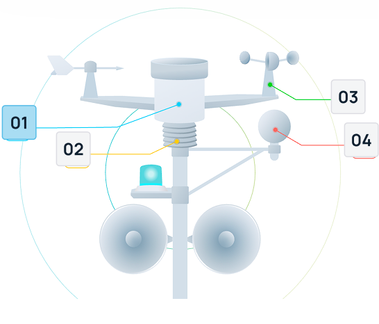
Remote system management from anywhere
Deploy high-quality PTZ (Pan-Tilt-Zoom) IP cameras designed for effortless setup and immediate operation through plug-and-play simplicity. This advanced design significantly reduces installation time and complexity, making sophisticated surveillance accessible for businesses of all sizes. Multiple cameras connect seamlessly to the network.
Remote system management from anywhere
Deploy high-quality PTZ (Pan-Tilt-Zoom) IP cameras designed for effortless setup and immediate operation through plug-and-play simplicity. This advanced design significantly reduces installation time and complexity, making sophisticated surveillance accessible for businesses of all sizes. Multiple cameras connect seamlessly to the network.
Remote system management from anywhere
Deploy high-quality PTZ (Pan-Tilt-Zoom) IP cameras designed for effortless setup and immediate operation through plug-and-play simplicity. This advanced design significantly reduces installation time and complexity, making sophisticated surveillance accessible for businesses of all sizes. Multiple cameras connect seamlessly to the network.
Remote system management from anywhere
Deploy high-quality PTZ (Pan-Tilt-Zoom) IP cameras designed for effortless setup and immediate operation through plug-and-play simplicity. This advanced design significantly reduces installation time and complexity, making sophisticated surveillance accessible for businesses of all sizes. Multiple cameras connect seamlessly to the network.
Learn From The Field

- Guides
Cal/OSHA Heat Regulations for Outdoor Workers: What California Employers Must Know
- Guides
GCSAA Lightning Safety Guidance for Golf Courses: A Complete Compliance Guide