Wireless Weather Station — Connectivity, Solar Power & Remote Deployment
cyclonePort is a professional wireless weather station that transmits real-time sensor data via cellular LTE, WiFi, or Ethernet to the RadarOmega cloud platform — accessible from any phone, tablet, or desktop, anywhere, without being tethered to a local network. Optional solar and battery backup enables deployment in locations with no grid power, making cyclonePort the professional wireless weather station for remote construction sites, rural emergency management networks, off-grid agricultural fields, and any facility where power and wired connectivity are unavailable.
Contents
01 What Is a Professional Wireless Weather Station?
02 Professional vs. Consumer Wireless Weather Stations — The Critical Differences
03 Wireless Connectivity Options — Cellular LTE, WiFi, and Ethernet
04 Why Cellular LTE Beats Facility WiFi for Outdoor Safety Deployments
05 Solar Powered Weather Stations — Off-Grid and Remote Deployment
06 Remote Deployment Use Cases — Where Wireless and Solar Matter Most
07 Redundancy and Data Integrity — What Happens When Connectivity Drops
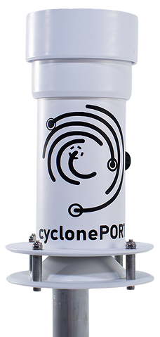
08 The cyclonePort Wireless Station — Hardware Overview
09 Accessing Wireless Station Data via RadarOmega
10 Deployment and Installation
11 System Specifications
12 Frequently Asked Questions

- Cellular LTE
Primary
- WiFi / Ethernet
- AC · Solar · Battery
01 What Is a Professional Wireless Weather Station?
A professional wireless weather station is a permanently deployed, calibrated sensor system that measures atmospheric conditions at a specific facility location and transmits that data in real time to a cloud platform — without requiring a wired connection to a local network or a manual download process. ‘Wireless’ refers to the data transmission path from the station to the cloud, not to the sensors themselves (which are hardwired to the station’s onboard processor for accuracy and reliability).
In a cyclonePort weather monitoring system, the term ‘wireless weather station’ spans an enormous range of products and use cases — from a $60 consumer unit with a wireless display console to a professional-grade surveillance system transmitting encrypted sensor data over cellular LTE to an enterprise cloud platform accessible by an entire organization. Understanding where cyclonePort sits in this spectrum, and why the connectivity architecture matters for professional operations, is the starting point for any deployment decision.
What ‘wireless’ means in a professional context For a consumer weather station, ‘wireless’ typically means the outdoor sensor unit transmits readings to an indoor display console via 433 MHz or 915 MHz RF — a range of 100–300 feet with no internet connectivity. For cyclonePort, ‘wireless’ means the station transmits every sensor reading, every second, to a secure cloud platform via industrial cellular LTE — accessible from any authorized device on the planet, with no range limitation, no local network dependency, and no manual data retrieval required. These are different technologies serving different purposes. |
cyclonePort wireless weather stations are deployed across school campuses, university athletics facilities, municipal emergency management networks, construction sites, utility operations, and agricultural operations — anywhere that organizations need real-time, site-specific atmospheric data accessible to multiple users simultaneously from multiple locations and devices.
02 Professional vs. Consumer Wireless Weather Stations — The Critical Differences
If you searched ‘wireless weather station’ expecting to find a product in the $100–$500 range for personal use, cyclonePort is not that product. This section explains why — and why organizations that start with consumer wireless stations almost always replace them when they realize what professional operations actually require.
| Characteristic | Consumer Wireless Station | cyclonePort Professional |
|---|---|---|
| Wireless transmission | RF to indoor display console (100–300 ft range; no internet) | Cellular LTE to cloud (unlimited range; internet-independent) |
| Multi-user access | One display console, one location | Unlimited users; any device; any location simultaneously |
| Data logging | Local memory, limited capacity, manual download | Continuous cloud archive; automatic; API-accessible; permanent retention |
| Alert delivery | Audible alarm on console only | SMS, email, push notification to any recipient list within seconds |
| Radar integration | None | Native integration with RadarOmega — station data on same map as NEXRAD radar |
| Live camera | None | HD PTZ camera with live streaming and remote pan-tilt-zoom control |
| WBGT measurement | Rarely; handheld required | Integrated sensor; automated logging; GHSA/NFHS/NCAA category display |
| Compliance documentation | None — no audit-ready records | Automated timestamped logs; exportable for regulatory submissions |
| Solar / off-grid deployment | Battery backup only; limited runtime | Solar panel + battery system designed for multi-year unattended operation |
| Calibration and QC | Factory set; no on-site validation | NIST-traceable calibration; automated quality control flags; anomaly detection |
| Support and maintenance | Self-service; consumer warranty | Managed subscription; remote diagnostics; firmware updates; lifecycle support |
| Typical price point | $100 – $500 one-time | Annual subscription; enterprise pricing; contact for quote |
The consumer station failure pattern organizations recognize too late A school district installs a consumer wireless weather station for $300. The outdoor sensor transmits readings to a console in the athletic trainer’s office. The athletic trainer has to be in the office to see the data. There is no push notification system, so she has to check manually. When she is at the practice field, she has no data. There is no WBGT sensor, so she uses a handheld device that requires setup and manual readings. There are no logged records for compliance documentation. When a student has a heat illness and the district is asked for weather records from that day, none exist. This is the moment districts call cyclonePort. |
03 Wireless Connectivity Options — Cellular LTE, WiFi, and Ethernet
cyclonePort supports three connectivity modes, each suited to different deployment scenarios. The choice of connectivity method is one of the first decisions in any deployment — and it affects reliability, installation complexity, IT involvement, and ongoing maintenance requirements.
Cellular LTE — The Default and Recommended Option
Cellular LTE is cyclonePort’s primary and recommended connectivity mode for the vast majority of deployments. The station contains an industrial-grade LTE modem with a SIM card managed by cyclonePort. Data transmits directly from the station to the RadarOmega cloud platform over the cellular network — no facility WiFi, no Ethernet cable, no IT department involvement required.
- No dependency on facility infrastructure: The station operates independently of the school’s, university’s, or construction site’s WiFi network. A network outage at the facility does not affect the station’s connectivity.
- Deploy anywhere with cellular coverage: Rooftops, athletic fields, remote parking structures, construction sites, agricultural fields — any location with 4G LTE coverage supports deployment, regardless of proximity to a building or network port.
- No IT coordination required: Because the station does not connect to the facility’s network, there is no firewall configuration, no network port request, no IT security review, and no ongoing IT maintenance. This eliminates the most common source of deployment delays for enterprise weather station projects.
- Managed connectivity: cyclonePort manages the cellular data plan as part of the subscription. Customers do not manage SIM cards, data plans, or carrier accounts.
WiFi — For Facilities with Reliable Outdoor Network Coverage
WiFi connectivity is available for deployments where a reliable, dedicated outdoor WiFi network covers the station location. This option is appropriate for university campuses with extensive outdoor wireless infrastructure, or indoor deployments in equipment rooms with good WiFi signal.
- Requires facility IT coordination: WiFi-connected stations must be added to the facility network, typically requiring IT department involvement for network access credentials, firewall rules, and ongoing network management.
- Dependent on facility network reliability: If the facility WiFi goes down — due to power outages, network maintenance, or ISP issues — the station loses connectivity. For safety-critical applications, this dependency is a significant risk.
- Not recommended for primary outdoor safety applications: An athletic facility’s outdoor WiFi network during a severe thunderstorm event is exactly when the weather station data is needed most — and exactly when a power-related network outage is most likely.
Ethernet — For Fixed Indoor or Shelter-Based Installations
Wired Ethernet connectivity is available for stations installed in fixed locations with direct Ethernet access — equipment rooms, rooftop shelters, or permanent structures with network infrastructure. Ethernet provides the most stable and highest-bandwidth connection, but requires physical cable routing and IT coordination.
- Maximum stability: A wired Ethernet connection is not subject to RF interference, signal strength variation, or wireless congestion — providing the most consistent transmission performance.
- Requires physical installation: Cable routing from the station location to a network port is required, adding installation complexity and cost. Not suitable for open-field or remote deployments.
- Appropriate for specific use cases: Broadcast meteorology operations centers, indoor emergency management facilities, and rooftop installations with existing network infrastructure.
04 Why Cellular LTE Beats Facility WiFi for Outdoor Safety Deployments
The choice between cellular and WiFi connectivity for a professional outdoor weather station is not primarily a technical preference — it is a safety architecture decision. For organizations using weather data to drive real-time safety protocols (lightning delays, heat illness prevention, high-wind shutdowns), the reliability of data transmission during the exact moments those protocols are needed is non-negotiable.
The Failure Mode That Matters
Facility WiFi networks fail for many reasons: power outages, ISP disruptions, network equipment failures, maintenance windows, and — critically — the same severe weather events that make the weather station most necessary. A lightning strike near a building can disrupt power and network equipment simultaneously. A severe thunderstorm that knocks out facility power also knocks out the WiFi access points that the weather station relies on for data transmission.
During these events, the safety officer or athletic director needs weather data the most. A WiFi-dependent station that loses connectivity during the storm is operationally useless at the exact moment it is operationally critical. Cellular LTE, operating on independent carrier infrastructure with geographic redundancy, continues transmitting through facility power and network outages.
The circular failure: WiFi weather stations fail when they are needed most An outdoor athletic facility installs a WiFi-connected weather station. A fast-moving thunderstorm approaches. At 3:47 PM, a lightning strike near the school knocks out power to the athletic wing — including the WiFi access points that the weather station uses for connectivity. At 3:48 PM, the station goes offline. At 3:49 PM, lightning is detected at 6 miles and the station would have fired its proximity alert — but it cannot, because it has no connection. At 3:52 PM, lightning strikes the football field. The cellular-connected alternative at the adjacent district school, unaffected by the local power outage, continues transmitting and fires the proximity alert at 3:49 PM. Practice at that school is suspended. Practice at the WiFi-dependent school is not, because the alert was never delivered. |
IT Independence as a Deployment Accelerator
Beyond reliability, cellular connectivity eliminates the most common source of weather station deployment delays in institutional settings: IT department coordination. A WiFi-connected station requires network access provisioning, firewall rule configuration, security review, and ongoing network management — processes that can take weeks or months in enterprise environments with formal change management procedures.
A cellular-connected cyclonePort station requires no IT involvement at any stage of deployment or operation. The station arrives preconfigured with its cellular connection managed by cyclonePort. It is mounted, powered, and online — transmitting live data to RadarOmega — without a single interaction with the facility’s IT department. For school districts managing complex network environments across multiple campuses, this independence is not a convenience: it is what makes a two-to-four week deployment timeline achievable.
05 Solar Powered Weather Stations — Off-Grid and Remote Deployment
A solar powered weather station combines photovoltaic panels and battery storage with a standard weather station sensor suite and wireless transmission system to enable continuous operation in locations with no access to grid power. cyclonePort’s solar power option extends its cellular LTE connectivity to completely off-grid environments — making it deployable anywhere on the surface of the earth with sufficient solar irradiance and cellular coverage.
How Solar Powered Weather Station Systems Work
The cyclonePort solar power kit consists of a photovoltaic solar panel (sized to the deployment location’s solar resource and the station’s power consumption), a charge controller that manages charging and prevents battery overcharge, and a sealed lead-acid or lithium battery pack that stores energy for operation during periods of low solar generation — nighttime, overcast days, and winter conditions with reduced daylight hours.
- Solar panel sizing: Panel wattage is selected based on the deployment location’s average daily solar irradiance and the station’s continuous power draw. Cyclical deployments (higher latitude, winter deployments) require larger panels or larger battery banks to maintain continuous operation through extended low-light periods.
- Battery autonomy: The battery bank is sized to provide a defined number of days of autonomous operation without solar input — typically 3–7 days for most deployments, longer for critical installations in high-latitude or high-cloud-cover environments.
- Charge controller: Manages the charge state of the battery, prevents overcharge, and provides low-battery protection to avoid deep discharge that shortens battery life. The station’s power consumption is optimized for continuous low-power operation between transmission intervals.
- Cold weather performance: Lithium battery chemistry is recommended for deployments in environments where temperatures regularly fall below 0°C — lead-acid batteries lose significant capacity in cold conditions, reducing the effective autonomy period. The charge controller compensates for temperature-dependent charging characteristics.
Solar Sizing Considerations by Deployment Type
| Deployment Type | Solar Configuration Notes |
|---|---|
| Mid-latitude school / municipal | Standard solar kit; 3–5 day battery autonomy; suitable for CONUS deployments from roughly 25°N to 50°N latitude |
| High-latitude / northern | Larger panel array; 5–7+ day battery autonomy; winter tilt angle optimization required to maximize low-angle solar gain from November through February |
| High-cloud-cover regions | Larger battery bank; conservative power budget; backup AC connection recommended for critical safety applications where extended overcast periods are common |
| Desert / high-irradiance regions | Standard or smaller panel; excellent solar resource but thermal management required — battery and electronics housing must maintain safe operating temperature in high-ambient conditions |
| Remote agricultural / research | Largest battery banks; most conservative power budgets; designed for months of unattended operation between site visits |
06 Remote Deployment Use Cases — Where Wireless and Solar Matter Most
The combination of cellular LTE connectivity and solar power makes cyclonePort deployable in environments where traditional wired weather stations are not feasible. These are the use cases where wireless and solar capability move from convenient feature to essential requirement.
Remote Emergency Management Networks
County and regional emergency management agencies often need weather observations from locations that are far from utility infrastructure — rural road intersections that flood during storms, remote reservoir monitoring points, wildland-urban interface areas for fire weather monitoring, and high-elevation sites that provide advance warning of mountain weather systems affecting populated valleys below.
A network of solar-powered, cellular-connected cyclonePort stations across a county provides the distributed observational network that emergency managers need for spatially comprehensive situational awareness — without the utility trenching, electrical permitting, and infrastructure construction that wired stations would require at each location. Data from every remote station appears on the same RadarOmega map as every other station, with the same real-time update rate and the same alert delivery system.
Remote and Unmanned Construction Sites
Large infrastructure projects — highway construction, pipeline installation, power line construction, bridge building — operate across linear corridors that extend for miles. Weather conditions at the far end of a 40-mile highway project may be entirely different from conditions at the project office. OSHA heat safety and lightning safety requirements apply at every location where workers are deployed — not just at locations convenient to the main construction facility.
Solar-powered cyclonePort stations can be deployed at multiple points along a construction corridor, providing heat index and lightning monitoring at each worker location without requiring power and network infrastructure at each site. Stations move with the project: as construction advances, the station is relocated to the active work zone. The cellular connection follows — no rewiring, no network reconfiguration.
Agricultural Field Monitoring
Agricultural weather monitoring requirements are inherently off-grid: the fields that need monitoring are where the crops are, not where the buildings are. Soil-adjacent temperature, humidity, and precipitation monitoring for irrigation management; frost prediction for crop protection scheduling; wind monitoring for pesticide and fertilizer application timing — all of these require sensors at field locations that may be miles from any electrical infrastructure.
Solar-powered cyclonePort stations provide the multi-parameter sensor suite that precision agriculture requires — temperature, humidity, dew point, wind speed and direction, rainfall, solar radiation — with cellular transmission to the cloud platform and API access for integration with irrigation controllers, farm management software, and agronomic decision tools. Data from every field station is accessible on a phone at any location, enabling farm managers to make irrigation, application, and harvest decisions remotely.
Remote Athletic Facilities and Practice Fields
School districts and universities often have practice fields, cross-country courses, track facilities, and outdoor athletic areas that are distant from the main campus buildings and have no utility infrastructure. A solar-powered, cellular-connected cyclonePort station at a remote practice field provides the same WBGT, lightning proximity, and heat index monitoring as a grid-powered station at the main campus — with the same alert delivery to the same recipient list — without requiring electrical service to the field location.
Broadcast Meteorology Remote Camera Locations
Television stations building regional weather camera networks need cameras at scenic or strategically important locations — mountain passes, rural highways, coastal areas, reservoir edges — that typically have no power or network infrastructure. A solar-powered cyclonePort station at each of these locations provides both the HD PTZ camera stream (for visual weather coverage) and the sensor data stream (for on-air conditions display) — powered by the sun, connected by cellular, accessible in RadarOmega alongside the broadcast studio’s primary radar platform.
07 Redundancy and Data Integrity — What Happens When Connectivity Drops
No wireless transmission system provides 100% uptime. Cellular networks experience brief coverage gaps, congestion during major events, and maintenance periods. WiFi networks fail with facility power. Even the most reliable connectivity architecture will occasionally experience an interruption. For a professional weather station whose data is used for compliance documentation and safety decision-making, the behavior during and after a connectivity interruption is as important as the normal-operation performance.
Local Buffering — No Data Gaps in the Archive
cyclonePort stations buffer sensor readings locally in onboard non-volatile memory when the transmission link is unavailable. Every sensor reading continues to be captured, timestamped, and stored locally at the normal one-second interval — the station does not stop logging when it loses connectivity. When the connection is restored, buffered records are transmitted to the RadarOmega cloud archive in chronological order, filling the gap that occurred during the outage.
The result is a continuous, unbroken archive with no gaps — indistinguishable from a record that was transmitted in real time throughout. For compliance documentation (WBGT logs for athletic association audits, heat index records for OSHA inspections) and forensic reconstruction (insurance claims, incident investigations), the absence of gaps is not a convenience: it is the difference between a defensible record and an incomplete one.
Local buffer capacity cyclonePort stations are designed with sufficient onboard storage to buffer 30–60 days of one-second sensor readings during an extended connectivity outage — far exceeding the duration of any realistic outage scenario. For solar-powered remote deployments where occasional cellular coverage gaps may occur, this buffer capacity ensures that seasonal data records are complete even if individual transmission sessions are brief. |
Dual-Connectivity Configurations
For applications where data continuity is particularly critical — emergency management networks, critical infrastructure monitoring, broadcast meteorology systems — cyclonePort supports dual-connectivity configurations that maintain data transmission through primary connection failures. A station configured with cellular LTE as the primary connection and WiFi as a secondary link automatically fails over to the WiFi connection if the cellular link is unavailable, and fails back to cellular when it is restored. This active-backup architecture minimizes transmission gaps for the most demanding applications.
08 The cyclonePort Wireless Station — Hardware Overview
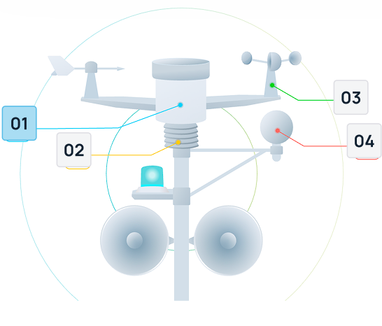
cyclonePort’s wireless weather station integrates sensors, data processing, connectivity, and power management into a single field-deployable system. All components are specified for continuous outdoor operation across the full range of North American climate conditions.
| Component | Specification |
|---|---|
| SENSORS | |
| Temperature / Humidity | ±0.2°C accuracy; ±2–3% RH; platinum RTD; multi-plate radiation-shielded housing with passive ventilation |
| Wind Speed / Direction | Ultrasonic preferred (no moving parts; no icing failure; sub-0.2-second response); mechanical cup-and-vane for power-constrained remote deployments |
| Barometric Pressure | ±0.5 hPa; absolute and sea-level equivalent; pressure trend computed continuously |
| Rain Gauge | Tipping-bucket; 0.01 in (0.2 mm) resolution; heated option for frozen precipitation environments |
| Lightning Detection | Real-time proximity detection and distance reporting; configurable alert thresholds |
| WBGT Sensor | Optional; wet bulb globe temperature; dry globe; natural wet bulb; GHSA/NFHS/NCAA risk category computed in real time |
| Solar Radiation / UV | Optional; incoming solar irradiance (W/m²) and UV index; input for evapotranspiration calculation |
| PTZ Camera | HD resolution; full pan-tilt-zoom; WiFi or Ethernet connection; static IP capable; multiple cameras per station supported |
| CONNECTIVITY | |
| Primary | Cellular 4G LTE; managed SIM; no customer IT involvement required; industrial modem |
| Secondary | WiFi (802.11 b/g/n/ac) or wired Ethernet; available as primary for fixed facility installations |
| Dual-connectivity | LTE primary + WiFi secondary for critical applications; automatic failover and failback |
| Transmission security | HTTPS encrypted; TLS 1.2+; certificate-pinned to RadarOmega cloud |
| POWER | |
| AC mains | Standard for grid-connected deployments; universal input voltage |
| Solar panel | Sized to deployment location solar resource; 12V system; adjustable tilt mounting |
| Battery | Sealed lead-acid (standard); lithium (cold-climate option); sized for 3–7 day autonomy without solar input |
| Charge controller | MPPT charge control; temperature compensation; battery health monitoring with alert on low-battery condition |
| Power consumption | Optimized for continuous low-power operation; configurable transmission intervals to extend battery life in constrained deployments |
| ENCLOSURE | |
| Environmental rating | IP65+ station housing; operating temperature –40°C to +60°C; UV-stabilized materials |
| Mounting | Pole/mast (standard); rooftop; fence post; existing structure attachment; WMO-compliant siting guidance provided |
| Sensor update rate | Every second; configurable averaging intervals (1, 2, 5, 10, 60 minutes) |
| DATA | |
| Platform | RadarOmega — iOS, Android, Windows, Mac, Linux; web browser access |
| Archive | Continuous cloud archive; full lifetime retention; no automatic deletion |
| Export | CSV and JSON; REST API; scheduled automated reports |
| Local buffer | 30–60 days of one-second readings during connectivity outage; automatic cloud sync on restoration |
09 Accessing Wireless Station Data via RadarOmega
Every cyclonePort wireless weather station — whether grid-powered, solar-powered, cellular-connected, or WiFi-connected — delivers its data to the same destination: RadarOmega, the professional weather platform used by 261,000+ subscribers. The connectivity method affects how data gets from the station to the cloud. The RadarOmega experience is identical regardless of how the station is connected.
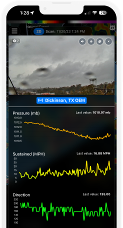
- Mobile access: iOS and Android apps provide the full station dashboard — live sensor readings, trend sparklines, active alerts, live camera feed, and historical chart viewer — from any phone or tablet, anywhere with data connectivity.
- Desktop access: Windows, Mac, and Linux desktop applications (included with any paid RadarOmega subscription) provide the full feature set on larger screens with multi-monitor support — suitable for emergency operations centers, dispatch centers, and broadcast weather rooms.
- Multi-station network: Organizations with multiple cyclonePort stations — regardless of each station’s connectivity type or power source — see all stations simultaneously on the RadarOmega map. A solar-powered remote EMA station appears alongside a grid-powered campus station with identical real-time data.
- No separate app for solar/remote stations: A solar-powered station in a remote agricultural field appears in RadarOmega identically to a grid-powered station on a school campus. There is no separate interface, no separate login, and no reduced feature set for remotely deployed stations.
- Alert delivery: Threshold alerts from solar-powered remote stations are delivered through the same SMS, email, and push notification system as grid-powered stations. A lightning proximity alert from a remote EMA station in the field reaches the same recipient list with the same delivery speed as an alert from a campus station.
What this means for multi-site remote networks A county emergency manager deploying six solar-powered cyclonePort stations across a rural jurisdiction — at remote road intersections, a reservoir dam, and two flood-prone creek crossings — sees all six stations on the RadarOmega map with real-time conditions at each location. When lightning approaches, the station closest to the storm fires the proximity alert first, identifying which part of the county is most at risk. The manager does not need to log into six separate dashboards or manage six separate alert configurations. One platform, one map, one alert system — regardless of how each individual station is powered or connected. |
10 Deployment and Installation
Standard Grid-Powered Cellular Deployment
- Site assessment: cyclonePort reviews the deployment location for siting compliance (clear exposure for wind sensors; radiation shield clearance for temperature; unobstructed rain gauge), cellular coverage verification, and mounting options.
- Hardware configuration: Station is pre-configured with cellular SIM, alert thresholds, and RadarOmega account linkage before shipping. Arrives ready to mount and power.
- Physical installation: Mounting on pole, rooftop, fence post, or existing structure. Sensor mast positioned at appropriate measurement heights per WMO guidance. Typical single-day installation by cyclonePort team or certified partner.
- Commissioning: Station appears in RadarOmega immediately on power-up. 7–14 day burn-in period for quality validation and baseline comparison against nearby reference data.
- Timeline: Contract to live data in RadarOmega in 2–4 weeks for standard deployments.
Solar-Powered Remote Deployment — Additional Considerations
- Solar resource assessment: cyclonePort evaluates the deployment location’s annual solar irradiance, seasonal variation, and horizon obstructions (trees, terrain) to size the solar panel and battery system appropriately for the latitude, cloud climatology, and station power budget.
- Panel orientation and tilt: Solar panel is mounted at the optimal tilt angle for the deployment latitude — typically equal to latitude for year-round optimization, or steeper for high-latitude winter deployments where maximum low-sun-angle gain is required.
- Battery and charge controller installation: Weatherproof enclosure housing the battery bank and charge controller, rated for the deployment temperature range. Lithium recommended for deployments below 0°C.
- Cellular coverage verification: Site survey confirms adequate LTE signal strength for reliable data transmission before hardware deployment. Signal repeaters or external antenna options available for marginal coverage locations.
- Remote diagnostics: All station health parameters — battery voltage, solar charge current, cellular signal strength, sensor status — are monitored remotely through the RadarOmega platform. Low-battery alerts notify cyclonePort and the customer before the station goes offline.
11 System Specifications
| Parameter | Specification |
|---|---|
| Connectivity — Primary | Cellular 4G LTE; managed SIM included; no customer IT involvement; industrial modem with external antenna option for marginal coverage locations |
| Connectivity — Secondary | WiFi (802.11 b/g/n/ac) or wired Ethernet; available as primary for fixed-facility installations |
| Connectivity — Dual | LTE + WiFi simultaneous; automatic failover to secondary on primary failure; automatic failback |
| Transmission security | HTTPS encrypted; TLS 1.2+ |
| Power — AC | Universal input; standard for grid-connected deployments |
| Power — Solar | Optional solar panel + MPPT charge controller + sealed battery; sized by deployment solar resource and station power budget |
| Power — Battery chemistry | Sealed lead-acid (standard, 0°C+); lithium iron phosphate (cold-climate, –20°C+) |
| Battery autonomy | 3–7 days without solar input (standard); up to 14+ days with extended battery bank option |
| Local data buffer | 30–60 days of 1-second readings during connectivity outage; automatic chronological sync on restoration |
| Sensor update rate | 1-second sampling all sensors; configurable averaging intervals |
| Operating temperature | –40°C to +60°C (station housing and sensors); battery chemistry limits apply for sub-zero deployments |
| Environmental rating | IP65+ enclosure; UV-stabilized housing; all-weather sensor designs |
| Temperature / Humidity | ±0.2°C; ±2–3% RH; radiation-shielded multi-plate housing |
| Wind speed | 0–75 m/s range; ±0.3 m/s (ultrasonic); sub-0.2-second gust response |
| Wind direction | 0–360° no dead zone; ±2–3°; vector-averaged; true-north referenced |
| Barometric pressure | ±0.5 hPa; absolute and sea-level equivalent; trend computed |
| Rain gauge | 0.01 in (0.2 mm) resolution; rate and accumulation; heated option |
| Lightning | Real-time detection and distance; configurable alert thresholds |
| WBGT (optional) | Wet bulb globe temperature; GHSA/NFHS/NCAA risk categories |
| PTZ camera (optional) | HD resolution; full pan-tilt-zoom; WiFi or Ethernet; multiple cameras supported |
| Platform | RadarOmega — iOS, Android, Windows, Mac, Linux; web browser |
| Archive | Permanent lifetime retention; CSV/JSON export; REST API; scheduled reports |
| Alert delivery | SMS, email, push notification; configurable thresholds and recipients; time-window scoping |
| Remote management | Full remote diagnostics, firmware updates, sensor health monitoring, camera PTZ control |
| Station lifespan | 10+ years with standard maintenance |
Specifications may vary by configuration. Contact cyclonePort for current engineering documentation.
Deploy a Wireless Weather Station at Your Facility cyclonePort wireless weather stations are available in grid-powered and solar-powered configurations for single-site and multi-site network deployments. Cellular LTE connectivity means no IT involvement, no facility network dependency, and no power infrastructure required for remote locations. Contact our team to configure connectivity, power, sensor suite, and alert settings for your specific deployment. info@cycloneport.com · 844-737-9328 · cycloneport.com/contact |
12 Frequently Asked Questions
What is a wireless weather station?
A wireless weather station is a system of calibrated sensors that measures atmospheric conditions and transmits the data without requiring a physical wired connection for data retrieval. In professional systems like cyclonePort, ‘wireless’ refers to cellular LTE, WiFi, or Ethernet transmission from the station to a cloud platform — delivering real-time data to any authorized device anywhere. In consumer products, ‘wireless’ typically means the outdoor sensor transmits readings via short-range radio frequency (RF) to an indoor display console, with no internet connectivity or multi-user access.
What is the difference between a WiFi weather station and a cellular weather station?
A WiFi weather station requires connection to a local WiFi network to transmit data to the internet — making it dependent on facility network reliability, requiring IT department involvement for configuration, and vulnerable to facility power and network outages. A cellular weather station contains its own LTE modem and SIM card, transmitting data independently of any facility network — deployable anywhere with cellular coverage, with no IT coordination required, and continuing to operate through facility power outages. For outdoor safety applications where data is needed during severe weather events, cellular connectivity is significantly more reliable than WiFi.
Can a weather station run on solar power?
Yes. cyclonePort offers optional solar and battery power kits for deployments without grid power access. The solar kit consists of a photovoltaic panel, MPPT charge controller, and sealed battery bank sized to the deployment location’s solar resource and the station’s power requirements. Standard configurations provide 3–7 days of autonomous operation without solar input. Lithium battery chemistry is recommended for cold-climate deployments (below 0°C). Solar-powered cyclonePort stations use cellular LTE for data transmission, making them fully off-grid — no power and no network infrastructure required at the deployment location.
Where can a solar powered weather station be deployed?
A solar-powered cyclonePort station can be deployed at any location with adequate solar irradiance and 4G LTE cellular coverage — which includes the vast majority of inhabited locations in North America. Typical solar deployment use cases include remote emergency management monitoring points, construction sites without utility power, agricultural fields for crop weather monitoring, remote athletic practice facilities, rural road and flood monitoring locations, and broadcast meteorology remote camera sites. The station is mounted on a pole or structure, the solar panel is oriented to the local sun path, and data begins transmitting to RadarOmega immediately on commissioning.
What happens to weather station data if the cellular connection drops?
cyclonePort stations buffer all sensor readings locally in non-volatile onboard memory when cellular connectivity is temporarily unavailable. Every reading continues to be captured and timestamped at the normal one-second interval. When the cellular connection is restored, buffered records are transmitted to the RadarOmega cloud archive in chronological order, producing a continuous, unbroken record with no gaps. Standard buffer capacity supports 30–60 days of one-second readings — far exceeding any realistic outage scenario.
Does a wireless weather station require IT department involvement?
For cellular LTE-connected cyclonePort stations — the default and recommended configuration — no IT involvement is required at any stage. The station arrives preconfigured with its cellular SIM and transmits data directly to RadarOmega over the cellular network, entirely independent of the facility’s WiFi or wired network infrastructure. There is no firewall configuration, no network access request, no security review, and no ongoing IT maintenance. For WiFi-connected configurations, IT coordination is required for network access provisioning and ongoing network management.
How is a professional wireless weather station different from a consumer wireless weather station?
Consumer wireless weather stations (Davis, Ambient Weather, AcuRite) transmit via short-range RF to an indoor display console, require manual data retrieval, provide no cloud archiving or API access, offer limited or no alerting capability, and lack the calibration standards and compliance documentation features that organizational operations require. Professional systems like cyclonePort transmit via cellular LTE to a cloud platform accessible by unlimited users simultaneously from any device, maintain a permanent automatic data archive, deliver threshold alerts via SMS and push notification, integrate natively with a professional radar app (RadarOmega), and provide the logged, exportable records needed for OSHA compliance, athletic association documentation, and insurance claims.
What sensors are included in the cyclonePort wireless weather station?
The standard cyclonePort wireless station measures temperature (±0.2°C accuracy, radiation-shielded), relative humidity (±2–3% RH), dew point (calculated), heat index (NWS Rothfusz formula with risk category display), wind speed (ultrasonic, no moving parts), wind direction (0–360° no dead zone), wind chill (NWS formula with frostbite risk category), barometric pressure (±0.5 hPa, with trend), and rainfall (0.01 in resolution, rate and accumulation). Optional add-ons include WBGT (wet bulb globe temperature with GHSA/NFHS/NCAA category display), lightning detection (real-time proximity alerting), solar radiation and UV index, and HD PTZ camera.
Related Instruments & Guides
Wind direction is one component of the complete cyclonePort weather station. Explore related instrument pages:
↗ Wind Meter & Anemometer — Wind speed, gust measurement, and Beaufort/Saffir-Simpson context
↗ Barometric Pressure Sensor — Pressure trend analysis for front detection alongside directional wind data
↗ Lightning Detection System — Lightning detection integrated with wind direction for complete storm awareness
↗ WBGT Monitor & Heat Stress Sensor — Heat stress monitoring with wind direction context for heat index and comfort
↗ Temperature Sensor — Air temperature monitoring alongside wind chill and heat index calculation
↗ Humidity Sensor & Hygrometer — Relative humidity and dew point with wind direction for air mass characterization
↗ Rain Gauge — Precipitation monitoring alongside wind direction for storm tracking and front passage documentation
Related Instruments & Guides
cyclonePort wireless weather stations integrate every sensor and system described in this series. Explore individual pages for technical depth on each component:
↗ Live Weather Monitoring Station — Complete platform overview: sensors, PTZ camera, radar integration, and real-time operations [link]
↗ Weather Station Data Logger — Continuous cloud archiving, compliance documentation, API export, and data ownership [link]
↗ RadarOmega Weather App — The professional radar and weather station app; 261,000+ subscribers; iOS, Android, and desktop [link]
↗ Temperature Sensor & Heat Index — Dry bulb temperature, heat index calculation, and NWS danger thresholds [link]
↗ WBGT Monitor & Heat Stress Sensor — Wet bulb globe temperature for athletic association compliance [link]
↗ Lightning Detection System — Strike proximity alerting, 30/30 rule protocols, and integration with RadarOmega [link]
↗ Wind Meter & Anemometer — Wind speed and gust measurement for storm approach and operational safety [link]
↗ Wind Vane & Wind Direction Sensor — Continuous 0–360° directional monitoring and wind shift alerting [link]
↗ Barometric Pressure Sensor — Pressure trend analysis as the earliest automated storm approach signal [link]
↗ Rain Gauge — Precipitation measurement for storm documentation and compliance records [link]
↗ Humidity Sensor & Hygrometer — Relative humidity, dew point, and heat index calculation [link]






Built for Severe Weather
Remote system management from anywhere
Deploy high-quality PTZ (Pan-Tilt-Zoom) IP cameras designed for effortless setup and immediate operation through plug-and-play simplicity. This advanced design significantly reduces installation time and complexity, making sophisticated surveillance accessible for businesses of all sizes. Multiple cameras connect seamlessly to the network.
Remote system management from anywhere
Deploy high-quality PTZ (Pan-Tilt-Zoom) IP cameras designed for effortless setup and immediate operation through plug-and-play simplicity. This advanced design significantly reduces installation time and complexity, making sophisticated surveillance accessible for businesses of all sizes. Multiple cameras connect seamlessly to the network.
Remote system management from anywhere
Deploy high-quality PTZ (Pan-Tilt-Zoom) IP cameras designed for effortless setup and immediate operation through plug-and-play simplicity. This advanced design significantly reduces installation time and complexity, making sophisticated surveillance accessible for businesses of all sizes. Multiple cameras connect seamlessly to the network.
Remote system management from anywhere
Deploy high-quality PTZ (Pan-Tilt-Zoom) IP cameras designed for effortless setup and immediate operation through plug-and-play simplicity. This advanced design significantly reduces installation time and complexity, making sophisticated surveillance accessible for businesses of all sizes. Multiple cameras connect seamlessly to the network.
Learn From The Field

- Guides
Cal/OSHA Heat Regulations for Outdoor Workers: What California Employers Must Know
- Guides
GCSAA Lightning Safety Guidance for Golf Courses: A Complete Compliance Guide